Typhoon Mawar approaching, strongest impact likely early next week
Typhoon Mawar approaching, strongest impact likely early next week
2023-05-25
The second typhoon of the season, Mawar, intensified into a severe typhoon Thursday morning after churning through Guam. The storm is still far from Taiwan, but forecasters are closely tracking the storm to predict its potential impact. The strongest impact from the storm will likely be felt next Monday to Wednesday.
Typhoon Mawar is on the prowl and even its periphery is intense, according to the Central Weather Bureau’s director.
The path of the storm will become clearer next week.
Kuan Shin-ping
CWB forecaster
It could veer toward Luzon Island. Or it could veer into the open sea when it’s a little closer, or a little farther. There’s a fairly large degree of divergence in the paths it could take. So whether it turns north next Monday or Tuesday will be most critical to our forecast.
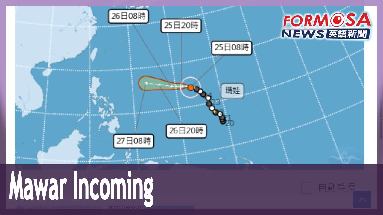
As of 2 p.m. on Thursday, the storm was located at 14.5 degrees north latitude and 142.8 degrees east longitude, moving west at a speed of 24 kilometers per hour. When it reaches the east coast of Luzon Island, in the seas southeast of Taiwan, it may start to turn north. From next Monday to Wednesday, the impact on Taiwan is likely to be the most severe.
Kuan Shin-ping
CWB forecaster
The southeast side
As it moves toward the southeast side of Taiwan, it could start to turn north. As it approaches, in the period from next Monday to next Wednesday, the typhoon’s peripheral effects will be felt mainly along the North Coast, including Keelung; the East Coast; the Hengchun Peninsula; and the greater Taipei area.
Most of this weekend won’t be affected by the typhoon, forecasters say. But starting Sunday afternoon, the approach of the storm’s periphery will drive in northeasterly winds, bringing rain to windward parts of Taiwan. The CWB says it may issue a sea warning next week.
Kuan Shin-ping
CWB forecaster
After it enters the outer East Sea and moves northeast, we may issue a sea warning. For now it appears that a typhoon warning won’t be a concern until after next Monday.
The CWB says it will continue tracking the storm, and that it’s still unclear when and how Mawar will make its northward turn.
"瑪娃"再開眼成強颱 下週不排除發布海警
2023-05-25
今年第二號颱風瑪娃週四上午再增強為強烈颱風,儘管目前距離台灣還有一段距離,但氣象局指出,分析颱風北轉時間點,就在週日及下週一,而影響最劇烈時間點,則可能在週一到週三,更不排除發布海上颱風警報!
氣象局長鄭明典PO文,指颱風瑪娃的颱風周圍雲系強烈。
至於瑪娃未來路徑怎麼走,下週是關鍵。
[[氣象局預報員 官欣平]]
“比較偏向呂宋島這邊,一直偏向外海更近一點的時候拐,或更遠一點的拐,其實這發散程度是相當大,所以比較偏向是下週一、下週二北轉這個趨勢的角度,是這預報最重要關鍵。”
週四下午兩點,在北緯14.5度,東經142.8度,以每小時24公里速度,向西進行,當颱風到呂宋島東側、台灣東南側海域,就可能開始北轉,尤其下週一到三影響台灣最劇烈。
[[氣象局預報員 官欣平]]
“比較偏東南邊這邊,開始要往北拐,比較接近的過程中,所以下週一到下週三這期間,受颱風外圍環流影響,(降雨)主要還是基隆北海岸、東半部、恆春半島、大台北地區。”
目前週末兩天,都還不會受到颱風影響,但週日下半天開始因為外圍環流逐漸接近,帶動東北風,迎風面會出現降雨,氣象局也不排除下週發布海上警報。
[[氣象局預報員 官欣平]]
“東方外海以後,往東北偏離這樣的情況,不排除發布海上颱風警報。不過目前看起來就是落在下週一之後,才會有颱風警報疑慮存在。”
瑪娃北轉時間、角度都還很難說,氣象局也將持續觀察。
Related News