First plum rains to bring lower temps, showers islandwide from Wednesday
First plum rains to bring lower temps, showers islandwide from Wednesday
2024-04-29
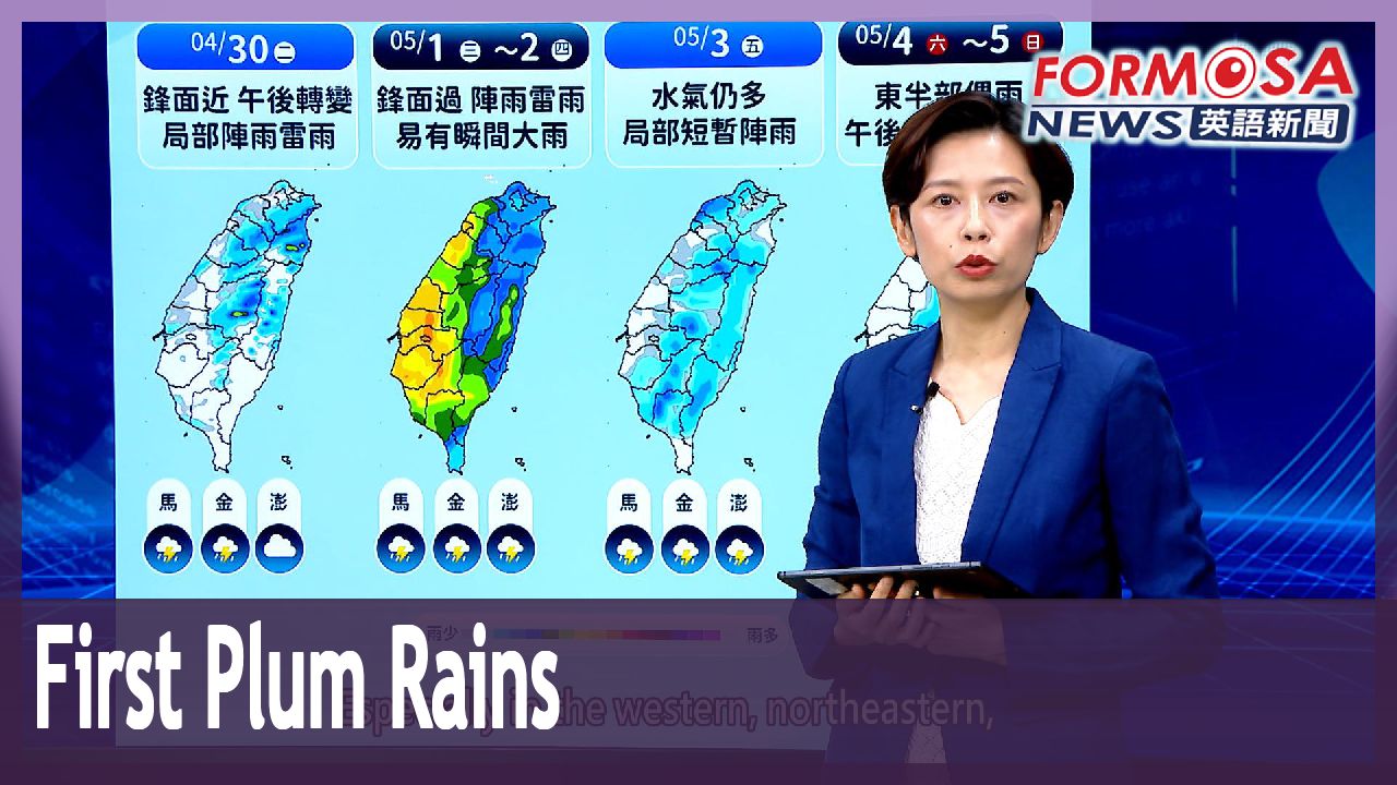
The first plum rains of the year are set to arrive on Wednesday, bringing slightly lower temperatures and showers islandwide. Forecasters expect heavier rains along the west coast and northeastern Taiwan. The front is set to linger until Friday.
Lo Ya-yin
CWA forecaster
The weather will become more unstable. We’re seeing rainfall pattern of brief showers or thunderstorms. Especially in the western, northeastern, and eastern regions, heavier rains are likely. We advise people to be cautious as the front passes, as it will bring rain and stronger northeasterly winds. Daytime and nighttime temperatures will drop slightly, making it a bit cooler. After the front passes on Friday, humidity levels will start to go down, but there will still be a chance of localized showers.
Earlier fronts have already provided some relief for the ongoing drought. In the south, Tsengwen Reservoir has risen to 35.47%. Nanhua Reservoir is nearing 30%. In the north, Shihmen Reservoir is at 27.9%, and the Second Baoshan Reservoir is at 36.5%. With more plum rains expected over the next two months, officials expect a significant increase to the water supply.
For more Taiwan news, tune in:
Sun to Fri at 9:30 pm on Channel 152
Tue to Sat at 1 am on Channel 53
首波梅雨鋒面將到! 週三.週四各地留意瞬間大雨
2024-04-29
今年第一道梅雨鋒面,週三、週四開始影響台灣,氣象署預估,將為全台帶來降雨,不過,西半部、東北部將出現較大雨勢,要留意瞬間大雨、短延時強降雨,氣溫也會跟著往下降,鋒面將一路影響到週五,雨勢才會逐漸趨緩。
[[氣象署技正 羅雅尹]]
“天氣會變得比較不穩定,從降雨的趨勢可以看到,都容易有短暫的陣雨,或者是雷雨出現,尤其西半部、東北部、東部地區,可能還會出現比較大的雨勢,就是要提醒大家留意,因為鋒面通過,造成下雨的關係,東北季風也稍微增強,所以各地白天的氣溫,或是早晚的氣溫也略微下降,天氣轉涼一些些,等到星期五鋒面通過之後,水氣開始慢慢的減少,不過各地在星期五的時候,還是會有一些局部性的陣雨出現”
先前的兩波鋒面,南北水庫都有進帳,曾文水庫蓄水率回升到35.47%、南化水庫逼近30%,北部的石門水庫蓄水率27.9%,寶二水庫也達到36.5%,接下來進入5月梅雨季,可望讓水庫再解渴。
更多新聞內容,請鎖定:
民視台灣台(152頻道)週日至週五晚上9:30
民視新聞台(53頻道)週二至週六凌晨1:00
Related News