Temps under 10 degrees expected in Northern Taiwan this week
Temps under 10 degrees expected in Northern Taiwan this week
2024-11-26
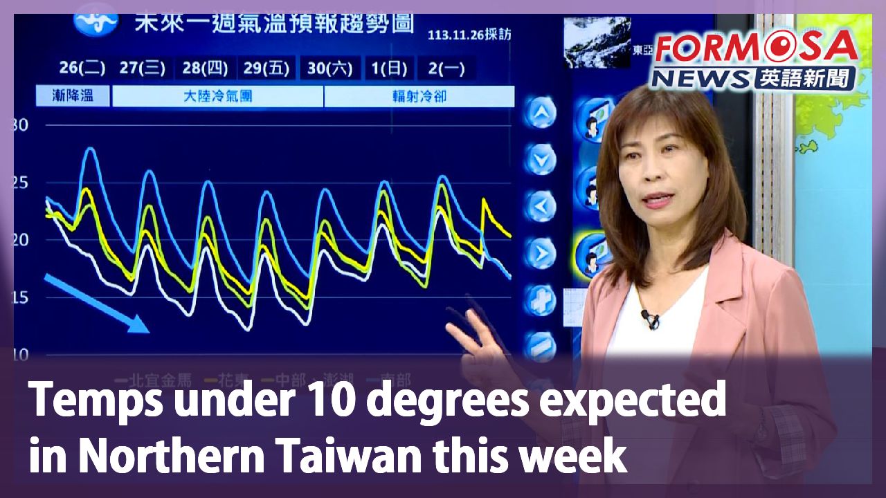
It’s about to get chilly this week, as a cold air mass approaches Taiwan from the north. Forecasters expect temps as low as 12 degrees starting Wednesday. And lows could further drop below 10 degrees in the north on Thursday and Friday. Already, Yushan awoke to a frosty landscape on Tuesday morning, as the mercury hit 0.4 degrees.
Frost covers the meteorological device, as if a white hat had been placed on top. Strong northeasterly winds sent temperatures in Yushan plummeting to just 0.4 degrees, turning the mountaintop a wintry white. Down in the plains, temps are sliding.
Wu Wan-hua
Central Weather Administration
Later in the day temperatures will drop in the north, northeast, Kinmen and Matsu. In Central and Southern Taiwan, Hualien, Taitung and Penghu, temps will rise somewhat until noon. They’ll gradually drop after midday and get lower as the day passes. We expect lows of 11 or 12 degrees in the northern half of the island.
A cold air mass is approaching Taiwan from the north, making for chilly nights. Its arrival coincides with lower atmospheric moisture, meaning dry and cold weather is on the forecast. Experts say the cold air mass could usher in a cold spell with lows of less than 10 degrees in unsheltered areas of Northern Taiwan on Thursday and Friday.
Wu Wan-hua
Central Weather Administration
On Wednesday, Thursday, Friday and through to Saturday morning, the North Pacific High will blow in cold air to Taiwan, with strong northeasterlies and cold continental air masses that only start weakening on Saturday and Sunday.
The cold weather may not recede until Sunday, and already, a new front is expected to pay call next Tuesday. It’s time to get the winter coats out of the closet.
For more Taiwan news, tune in:
Sun to Fri at 9:30 pm on Channel 152
Tue to Sat at 1 am on Channel 53
大陸冷氣團報到越晚越冷! 週四週五北部下探10度
2024-11-26
天氣要變冷了,今天鋒面通過,東北季風增強,加上大陸冷氣團明天南下,下午開始,全台各地都會感受到氣溫驟降,而且是越晚越冷,氣象署表示明天可能會出現12度低溫,週四週五是最冷時候,北部空曠地區恐怕會出現10度以下低溫!今天一早玉山氣象站的溫度只有0.4度,應經經出現結霜現象,讓山頭出現雪白美景!
氣象儀器上佈滿一層霜,彷如戴上白色帽子,受到東北季風增加,玉山一早,出現0.4度低溫,整座山頭被染成超美的雪白色,但不只高山,全台各地氣溫都準備溜滑梯。
[[氣象署簡任技正 伍婉華]]
“以今天來說,北部、東北部和金門、馬祖,溫度會越晚越冷,其他各地像中南部、花東、澎湖,到中午溫度還會上升一些些,但下午溫度也會漸漸下降,一樣在下午以後會越晚越冷,我們預估的最低氣溫,在中部以北地區,11、12度左右”
氣象署預告,大陸冷氣團即將南下,恐怕越晚越冷,好在水氣會越來越少,轉成乾冷的天氣型態,不少氣象專家也表示大陸冷氣團還會再發威,恐怕將達到強烈冷氣團的等級,周四、周五,苗栗以北的空曠地方,恐怕剩下不到十度。
[[氣象署簡任技正 伍婉華]]
“星期三、星期四、星期五,一直到星期六清晨,北方高壓會帶來大陸冷氣團,帶來比較強的東北風大陸冷氣團,影響我們的天氣,而這波大陸冷氣團星期六、星期天,才會減弱”
這麼大陸冷氣團,恐怕等到周日才會慢慢減弱,但下周二有新一波鋒面報到,民眾恐怕得準備好禦寒衣物,正是迎接冬天的到來。
更多新聞內容,請鎖定:
民視台灣台(152頻道)週日至週五晚上9:30
民視新聞台(53頻道)週二至週六凌晨1:00
Related News