Barrier lake in Hualien just 7km from site of Matai’an flood
Barrier lake in Hualien just 7km from site of Matai’an flood
2026-06-22
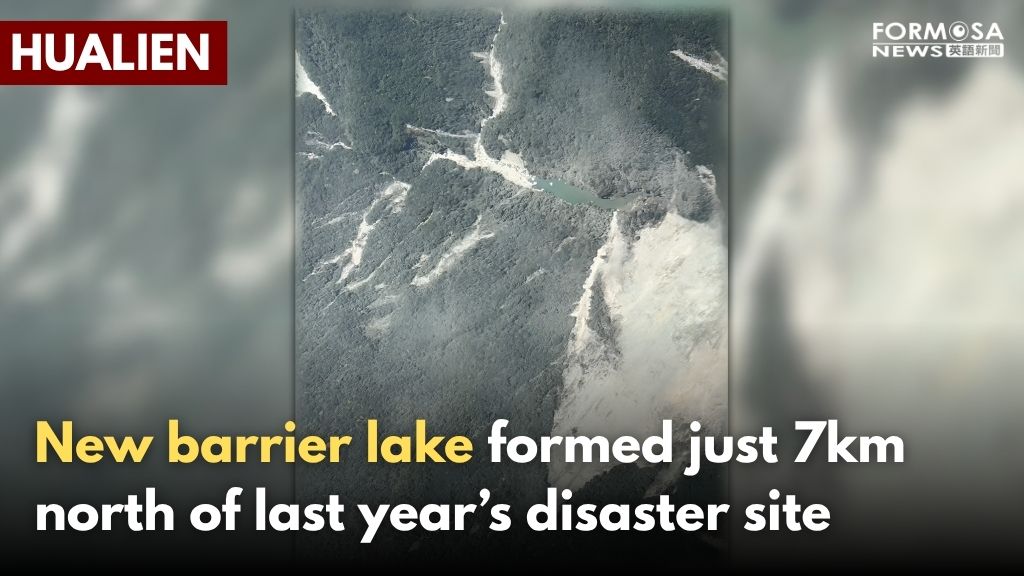
Ever since last year’s Matai’an Creek flood in Hualien, the Forestry and Nature Conservation Agency has regularly monitored the surrounding area to prevent a similar disaster from happening again, and now the agency has discovered a new 3-hectare barrier lake located just 7km to the north of the site of last year’s disaster.
Deep in the mountains in Hualien, an aerial photograph reveals that a 3-hectare barrier lake has formed next to a large landslide. The barrier lake is only 7km to the north of where the Matai’an barrier lake breach disaster occurred last year.
Huang Chium-tse
Forestry and Nature Conservation Agency
There’s an elevation difference between the riverbed and the settlement downstream, so currently there’s no need to be overly concerned. Our evaluation is that the barrier lake’s location is very deep in the mountains and it’s not accessible by road, which is why we haven’t recently had anybody get close to that body of water.
Ever since the Matai’an Creek disaster, the Forestry and Nature Conservation Agency has routinely monitored the nearby area. The agency found a new barrier lake where the upper reaches of Wanli Creek passes through Lintianshan Forestry Culture Park. The body of water is deeper in the mountains than last year’s barrier lake at Matai’an Creek. The closest settlement is Wanrung Village at 22km away; and there’s also Xibao Bridge and Wanli Creek Bridge, which are 24km and 27km away, respectively. Many landslides have occurred near Wanrung Village, so the closest cars can get is 3.5km, and there’s no hiking path that leads to the body of water. As a result, a helicopter was sent to inspect the area on Monday morning.
Huang Chium-tse
Forestry and Nature Conservation Agency
Based on preliminary data, we’ve already notified the Ninth River Management Branch, and they’ll help us monitor water levels. Hualien County Government, Fenglin Township Office, and Wanrung Township Office were also immediately notified about the situation.
Hsieh Yu-chen
Borough Warden in Fenglin Township
The words “barrier lake” strike fear in the hearts of everyone, so I personally went door-to-door, notifying every resident that a barrier lake has formed, and the riverbed isn’t all that far from us.
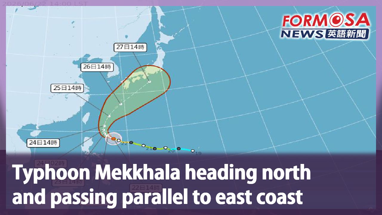
With Typhoon Mekkhala—the year’s seventh typhoon—looming, the Forestry and Nature Conservation Agency won’t be taking any chances, which is why an emergency response team has been formed in order to closely observe the barrier lake’s water levels as well as the possibility of a breach.
For more Taiwan news, tune in:
Mon to Fri at 9:30 pm on Channel 152
Tue to Sat at 1 am on Channel 53
#hualien #barrierlake #typhoon #disastermitigaiton #flood
馬太鞍溪崩塌地北方"新生堰塞湖" 直升機出動勘察
2026-06-22
去年花蓮馬太鞍堰塞湖溢流事件後,林保署都有進行例行監測,週日發現,在更北方的七公里處、萬里溪上游,有一處新生成的堰塞湖,面積約3公頃大。雖然評估沒有立即危險,但相關單位不敢大意,今天出動直升機勘察,也通知花蓮縣府和下游居民,多加留意。
從空拍圖中可以看到,山區大片土石崩塌的左邊,出現一座面積約3公頃大、新的堰塞湖,地點就在去年花蓮馬太鞍溪崩塌處北邊7公里。
[[林保署花蓮分署長 黃群策]]
“下游的位置大概河床都有高程差,目前不用過度擔心。在評估之後,發現它非常深山,沒有路到達,所以人員短期無法接近。”
馬太鞍溪事件後,林保署進行例行監測,發現萬里溪上游,在林田山事業區交界處,有新的堰塞湖,比之前馬太鞍溪堰塞湖還深山,距離最近的萬榮村約22公里,分別離西寶大橋、萬里溪橋各24公里以及27公里。由於萬榮林道多處發生崩塌,車輛只能到距離湖體3.5公里處,也沒有徒步道路能抵達,因此週一上午派出直升機勘查。
[[林保署花蓮分署長 黃群策]]
“初步的資料,已通知下游的水利署九河分署,幫忙觀察水位,即時通報花蓮縣政府,鳳林鎮公所及萬榮鄉公所。”
[[鳳林鎮森榮里長 謝玉珍]]
“堰塞湖三個字大家都怕,挨家挨戶我就去通知,跟他們講有堰塞湖形成,河床也離我們很近。”
由於今年第七號颱風米克拉已生成,林保署不敢大意,成立緊急應變小組,密切觀察壩體高度和是否溢流,提前做好準備。
更多新聞內容,請鎖定:
民視台灣台(152頻道)週一至週五晚上9:30
民視新聞台(53頻道)週二至週六凌晨1:00
Related News