Tropical depression expected to strengthen into storm by Sunday
Tropical depression expected to strengthen into storm by Sunday
2025-09-18
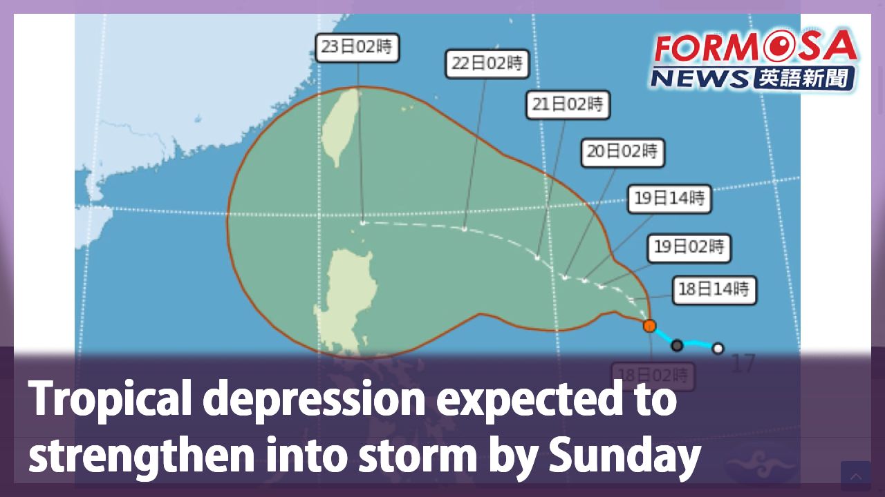
A tropical depression near the Philippines has strengthened into the 17th named storm of the year, called Mitag. Though that storm is not expected to have any direct impact on Taiwan, meteorologists are keeping an eye on another tropical depression in the area. If this latter one also strengthens into a storm, it will be called Ragasa, and it could end up becoming a typhoon. Let’s hear from the Central Weather Administration.
Lee Ming-hsiang
Central Weather Administration
After it strengthens into a storm, by Monday, its periphery will begin to affect the weather in Taiwan. It could even strengthen into a typhoon. It will be closest to Taiwan from Monday to Wednesday, so we should all keep an eye on future forecasts. The storm will be closest to Taiwan on the night of Tuesday to Wednesday. Hualien, Taitung, and the Hengchun Peninsula could get hit by strong showers and thunderstorms, and downpours will last quite long and be quite heavy. We might even see localized extremely heavy rains. In Yilan and Pingtung, and in other mountainous areas, there could also be heavy showers.
Experts say a sea warning could be issued as early as Sunday, with a land warning to follow as early as Monday.
For more Taiwan news, tune in:
Mon to Fri at 9:30 pm on Channel 152
Tue to Sat at 1 am on Channel 53
#storm #tropicalstorm #depression #weather #rain #rainy #taiwan #typhoon
第17號"米塔"颱風形成 "樺加沙"可能週日發海警
2025-09-18
西北太平洋上有三個熱低壓,其中菲律賓附近的熱低壓TD20,週四下午正式形成第17號颱風「米塔」,不過,對台灣沒有直接影響,反倒是熱低壓TD21,可能接力成為第18號颱風「樺加沙」,未來還有機會增強為中颱。
[[中央氣象署預報員 李名翔]]
“(編號第21號的熱低壓形成颱風後)預計下週一的時候,受到外圍環流影響,台灣的天氣也會開始有一些變化,而且到時候它的強度也可能會增強到中度颱風的等級。特別是週一到週三,距離台灣相對是比較近的,也要留意它後期的一個預報資訊。在週二到週三的清晨,相對是這個颱風,距離台灣最接近的時候。花東還有恆春半島,都要留意可能會有陣雨或雷雨,降雨的時間也是比較偏長的,並且有大雨,甚至是局部豪雨的情況。那尤其是在宜蘭還有屏東地區,以及各地的山區,可能也會有局部大雨的現象。”
TD21一旦增強為颱風,氣象專家預估,最快週日就會發海警,下週一發陸警。
更多新聞內容,請鎖定:
民視台灣台(152頻道)週一至週五晚上9:30
民視新聞台(53頻道)週二至週六凌晨1:00
Related News