After 9 years, farmers successfully harvest wasabi again
Wasabi was once grown in the scenic mountains of Alishan at a high altitude and was a local specialty loved by Japanese and Taiwanese people alike. However, it was also grown on state-owned land and tolerated for decades, until the then-Forestry Bureau banned the cultivation of wasabi on altitudes of 2,200m and up near the end of 2016. In 2023, the Tsou people established a cooperative to try grow the crop again at mid-altitude area. Their efforts have paid off and a newly developed wasabi cultivar is expected to become the next local money spinner after high mountain tea and coffee. Our weekly special report.
Chen Meng-liang
Japanese cuisine chef
The taste is good. It’s basically the same as before. A customer brought some down before and it wasn’t as great. But this one’s not bad. It’s sweet and spicy at the same time.
After trying some, this experienced Japanese chef gave his seal of approval to the new variety of Alishan wasabi.
Chen Meng-liang
Japanese cuisine chef
Fresh wasabi is spicy and sweet, but it doesn’t sting. It’s milder. Whereas powdered wasabi has chemical additives more or less. So while it’s spicy, it also burns. But not with fresh wasabi: when you mix it with soy sauce, it even gives the soy sauce a slight sweetness that lingers.
This exquisite taste didn’t come easily, all because wasabi cultivation was banned on Alishan in 2017.
Chen Meng-liang
Japanese cuisine chef
It’s a pity. Customers keep asking why we don’t offer fresh wasabi anymore. Sometimes they order bluefin tuna, which should be paired with Alishan wasabi, but it’s just not possible.
Wasabi used to be one of Alishan’s most iconic produce. The holy trinity of Alishan were the sacred trees, taking the forest railway to catch the sunrise, and wasabi.
Liang Pi-chu
Alishan wasabi farmer
In the past, when visitors come up here, the first thing they look for is wasabi. It was an Alishan specialty that only grows here and exported to Japan.
Mazuma wasabi from Alishan has great quality and taste, and was therefore popular in the Japanese market. It was also pricey, at more than NT$1,000 per kilo.
Huang Chin-cheng
Alishan wasabi farmer
Back then, at the height of wasabi cultivation on Alishan, everyone living on the mountains, Han Chinese and Indigenous alike, relied on growing wasabi for their livelihoods. Apart from bamboo shoots, wasabi was probably the most widely cultivated. And it’s not just about the economic value. It’s such a great crop and kept so many of us alive.
Liang Pi-chu
Alishan wasabi farmer
Before, we only had scooters and carts. After we started growing wasabi, we could buy mircovans, then sedans, and we could start doing repairs around the house too. It really allowed us mountain residents make a good living.
Wasabi can only be grown in humid, shady and cool areas between 12 and 18 degrees. Not only that, it also takes one-and-a-half to two years before it can be cultivated. Due to the stringent conditions required, in Taiwan they’re almost exclusively grown in Alishan at around 2,200m above sea level, in state-owned forests. That’s also where the controversy begins: the crop may be an important source of income for farmers, but the government grew increasingly concerned about the impact of wasabi cultivation on the local ecosystem.
Nine years ago, we also reported on the wasabi farms at the time.
After a fierce tug-of-war, the Forestry Bureau, now the Forestry Conservation Administration, reclaimed all state-owned forest land in 2017 and banned wasabi cultivation. It also eradicated all wasabi plants, thus bringing an end to the once-thriving industry.
Huang Chin-cheng
Alishan wasabi farmer
When wasabi cultivation was brought to a halt, all young people moved out in the next few years. That means there wasn’t a way they were going to make a living in the mountains.
Now, after nine years, can the industry be revived?
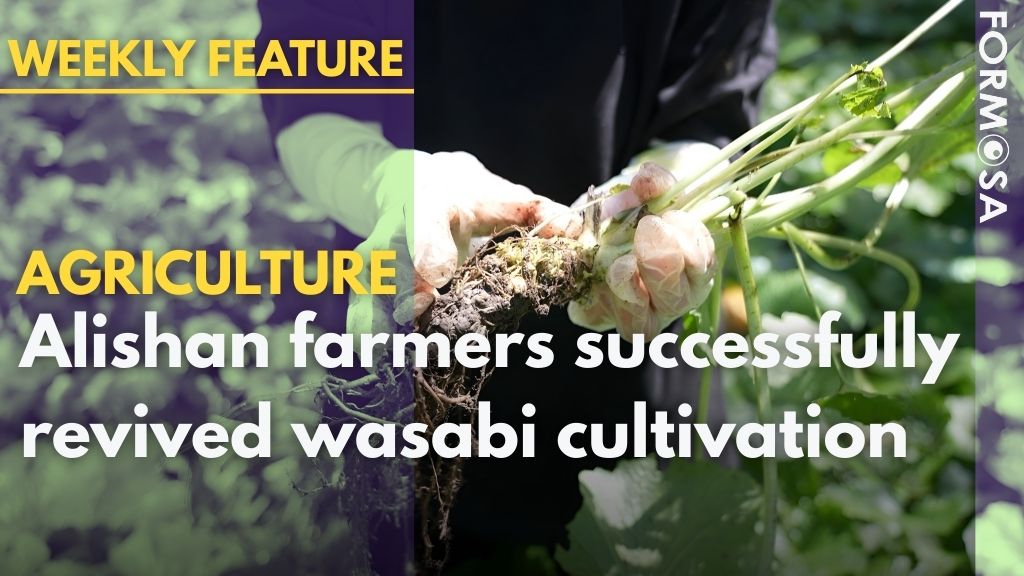
We’re now at Alishan Wasabi Cooperative chair, An Shu-mei’s wasabi farm. She’s set up a screen house to create a suitable growing environment for wasabi plants.
Here it is, the coveted wasabi.
An Shu-mei
Alishan Wasabi Cooperative chair
I’m pulling it up like this. The roots are free of disease. It’s really healthy, without any disease. This is the wasabi rhizome that will be ground into wasabi paste, it’s this section here.
The wasabi rhizome is still covered in soil, but reveals itself after rinsing.
An Shu-mei was a pastor for the Tsou people in Alishan. To help support the local economy, she started growing wasabi a few years ago, at the village of Lalauya, 1,200m above sea level.
An Shu-mei
Alishan Wasabi Cooperative chair
Our wasabi was famous and had great economic value. There has to be a cash crop that allows our tribespeople to make a living. It’s also the question of protecting our land, our Indigenous reserve. The plot of land next to Lalauya was already sold to Han Chinese people. The Indigenous front is only a cover. We keep losing so much of our productive land.
An Shu-mei established the cooperative in 2023 to encourage fellow villagers to get into the trade. But her efforts did not pay off in the beginning.
An Shu-mei
Alishan Wasabi Cooperative chair
People were skeptical. Everyone said to me, “Even Dr. Lee failed. What made you think you’d succeed?” I’ve also heard that many biotech companies tried to cultivate wasabi and even invited our villagers to try planting them too, but even the companies gave up.
People didn’t mean to be dismissive. There were simply too many cases of failure.
Liao Hui-fen
National Chiayi University professor of biochemical science
Most wasabi cultivars cannot adapt to the altitudes of 1,200m to 2,200m. So we had to select and breed a cultivar ourselves. The wasabi cultivar grown on Alishan now can be considered a new cultivar. It’s handpicked by us in Taiwan. It’s not what the Japanese had, the Mazuma or Shimane cultivars. So the Alishan wasabi cultivar is really precious. It’s suited to the environment here.
An Shu-mei not only had to select a new cultivar, she also had to create quality seedlings. With subsidies from the Agriculture and Food Agency, the cooperative built a smart greenhouse for cultivating healthy and bacteria-free seedlings, which will then be allocated to cooperative members to grow in their own screen houses.
But that’s still only the beginning. There are still many challenges that await wasabi farmers.
Wang Chi-sheng
Alishan wasabi cooperative member
The high-altitude farms were colder and didn’t have an issue with pests. But now that we’re growing here, it’s harder to fight against pests and disease. This is what we’re dealing with.
Yang Cin-sian
Taiwan Agricultural Research Institute
Moving wasabi to a place between 1,000m and 2,000m above the sea where most Indigenous reserves are poses several challenges. First, the temperatures are higher, and the duration of high temperatures is also much longer. That’s the first challenge. Second, the insect population differs. Within this area, pest infections are much more common and varied than higher up in the mountains.
Growing healthy wasabi crops in lower-lying regions was an immense challenge, but the cooperative, now with more than 20 members, persisted.
Towards the end of 2024, the cooperative finally harvested the first batch of wasabi crops and immediately attracted wide attention. Even Japanese buyers hurried to score them.
Liao Hui-fen
National Chiayi University professor of biochemical science
They’ve been missing the Alishan wasabi from before. So as soon as they heard that we’ve started growing it again, they were excited to come and see. They actually love our wasabi. When they came before, they asked for long-term purchasing contracts even for the leaves and stems. But because our farms are still small and we can’t guarantee a certain yield, it’s not feasible for us to accept large orders at the moment.
The challenge now is for the yield to catch up with demand. Wasabi already sells for more than NT$6,000 per kg, and can reach over NT$10,000 for produce of high quality. This has become a great source of motivation for Indigenous farmers.
Liang Pi-chu
Alishan wasabi farmer
Although those of us who are active in wasabi cultivation belong to the older generation, there are already a couple of youngsters who’ve joined our cooperative. I also hope that young people can help us succeed.
Nine years has passed since wasabi cultivation on Alishan was uprooted. What does the state-owned land now look like?
The wasabi plantation reclaimed by the Forestry Bureau at that time covered nearly 300 hectares. Today, no trace of the former plantation can be seen.
Ho Wen-I
Forestry and Nature Conservation Agency technician
It’s good. We had hope to retain its original state, meaning a larger natural habitat for wild animals. Here we’re starting to capture images of the Formosan black bear, as well as other commonly spotted wild animals, including wild boars, Reeves’s muntjacs, goats, yellow-throated martens, crab-eating mongooses and even pangolins, really diverse fauna.
After nine years, it seems that both wasabi farmers and environmentalists have reached a happy ending.
For more Taiwan news, tune in:
Mon to Fri at 9:30 pm on Channel 152
Tue to Sat at 1 am on Channel 53
#agriculture #taiwan #alishan #wasabi #sashimi #sushi
2026-01-26