Taoyuan temple celebration blends tradition and innovation to attract youth
The Daxi Daxi festival is held annually in Taoyuan to celebrate the birthday of a prominent folk religion deity. It’s always been a major event, but in recent years organizers have noticed that most of the participants are not exactly young. Amid concerns that the festival is losing its appeal, organizers began looking for ways to modernize the event. By cooperating with young designers, the festival now features electronic music, colorful imagery and futuristic robotic costumes, which seem to have kicked off a revival. But how does the festival balance tradition with innovation? Join us as we hear from the festival’s performers, designers and organizers on how creativity is bringing new life to Daxi Daxi.
It’s the start of the lunar calendar’s sixth month, and as usual for this time of year, crowds are gathering at Puji Temple in Taoyuan’s Daxi District. Temple officials are also here, paying their respects to folk deity Lord Guan.
The 24th day of the lunar calendar’s sixth month is Daxi Daxi – a folk festival celebrating Lord Guan’s birthday. The festival is the temple’s biggest event of the year.
For the people of Daxi District, the lively festival is like a second Lunar New Year. Lord Guan’s birthday and the eve of that day – which this year fall on July 21 and 22 – are the grand finale of the festival, when Lord Guan goes on tour. However, Daxi Daxi is a 21-day affair, and revelers celebrate throughout the full three weeks.
Under the skillful command of temple performers, auspicious dragons and lions dance about. Throughout the day, 31 local temple performance troupes fill Daxi Old Street commanding a captivating sight. At night, the festival continues back at the temple, with a vibrant light show and electronic music party.
Traditional folk music is adapted to modern styles, inviting revelers both young and old to throw up their hands and give in to the atmosphere.
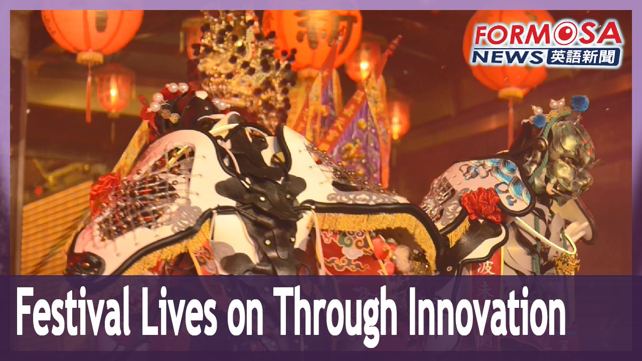
Two dancers clad in robotic deity costumes step out from the shadows and the crowd goes wild. Representing the deity generals Zhou Cang and Guan Ping, the dancers’ costumes emit light from their breastplates and upper backs, as they dance in unison before the crowd.
This modernized festival – which has proved popular with younger crowds – is the result of nearly five years of development. Puji Temple began working with costume and exhibit designers in 2019 to come up with new performances for the festival. This year the organizers introduced a festival theme song, and are holding concurrent exhibitions near the temple. Daxi Daxi has a history spanning over 100 years, and this year may be Lord Guan’s most fashionable birthday to date – but will the district’s elderly be able to accept the changes?
Designers struggle with how to strike a balance between tradition and innovation.
Nestled in the industrial area of Taipei’s Shilin District, is the studio of designer Lee Yu-sheng – one of the architects of the modern Daxi Daxi festival. Stepping into the studio, one’s attention is immediately drawn to the two robotic deity costumes from the festival.
Lee Yu-sheng
Costume designer
These two divine generals greet people as they come in. They are the all-seeing god and the all-hearing god. They are like two glowing giants in the night. For people who don these costumes, they also light the way. I think it’s a way of using modern technology, to manifest divine power – I guess by relying on light and sound.
From the robotic divine generals, to the depictions of Taiwanese animal deities that debuted at this year’s Daxi Daxi, and even the festival banner – all of these creations are the works of Lee.
Lee Yu-sheng
Costume designer
Lord Guan is Puji Temple’s main deity, and at the very top everyone can see the Five Tiger Generals. These traditional folk beliefs, and traditional temple festivals – people are most worried that these things will be lost to time, just like what we saw with the ban on incense at temples. So, there are young people bringing new takes and innovations to these traditions, like what we are seeing at Daxi Daxi, and this has been well received.
Reform is not without struggle. Innovation must contend with strong traditions, and change can only take place through compromise.
This year, organizers invited Hsinchu City’s protecting deity, Cheng Huang Ye, as a special guest at Daxi Daxi. In traditional fashion, the Hsinchu City God Temple’s administrators wanted to have auspicious notices pasted up along Daxi’s streets to announce Cheng Huang Ye’s procession route. To their surprise, the request was met with reservations from some festival organizers.
Liu Chen-jung
Daxi Daxi organizer
When it comes to the elderly, you are dealing with a background of a hundred years. In that hundred years are many hundreds of years of stories. With religious matters they may feel that you don’t understand them. You have to do lots of homework, and you have to tell them, “I may not fully understand you, but I will try my best. You can teach me.”
Puji Temple administrators and performers agreed to the Hsinchu temple’s request, deciding it could inject a new element into the celebration. But how much could Daxi Daxi be reformed, and what should the bottom line be? Only trial and error would tell.
Hsieh Chang-ming
Puji Temple chairman
Some committee members were concerned that, on the folding card used to hold the festival’s commemorative talisman, only the words “Daxi Daxi” were written – the words “Puji Temple” were absent. The committee members argued that the talismans are meant to be taken to the temple to be blessed, and then taken home to provide protection. So, the committee members took issue with only including the words “Daxi Daxi” on the card.
Liu Chen-jung
Daxi Daxi organizer
In the beginning he even said he didn’t want to use the card. He said, “This is no good, I’m not paying for this.” So, I made a very elegant sticker to put on the cards, which had “Puji Temple” written in both Chinese and English. It reminded him of a stamp, and it fit the card perfectly.
Disputes are inevitable in the process of reforming Daxi Daxi, but communication and reconciliation are part of that process too – and the hard work of these innovative youth has not gone unnoticed by Puji Temple.
Chiang Chih-cheng
Daxi Folk Arts Association
Even when people complain to them, they don’t snap – they’re very dedicated. When the performers come to them with requirements, they accommodate everyone. They rarely say “No.”
Hsieh Chang-ming
Puji Temple chairman
They are really quite hard-working. For example, when we are filming advertisements, or hosting activities where our deity shows up, they will be there working very hard – I’ve seen it. So, whenever some small problem comes up, we just take our time and resolve it.
Through respect for tradition and trust in innovation, the Daxi Daxi festival evolves and improves.
Watching the troupe perform one can learn about the divine generals. If that’s not enough, visitors can also watch the monitors and follow the movements of troupe captain Chang Shu-wu.
Chang Shu-wu
Jia Tian Temple director
About 10 years ago I realized something. Those carrying around the sedan chair on pilgrimages are all in their 40s, 50s or older. There’s nobody younger than that. It made me think, what can we do to ensure the preservation of this culture?
Hoping to pass on the temple’s traditions to future generations, Chang took on the task of training performers for Daxi Daxi, and established a course to train performers outside of the festival period. Chang also wrote his own book to outline the steps of the performance.
Chang Shu-wu
Jia Tian Temple director
In the past, all this was passed on orally. What I worry about now is, when I’m teaching this stuff, what if the student forgets some small detail. Then when they teach someone, that person forgets a detail, and so on. So, our thinking is, we need to take the visual aspects of this performance and transform them into words for preservation – turning the performance into a script. I hope that what I teach is fellow teachers, and not just performers.
Through those who pass on the temple’s traditions, festivals like Daxi Daxi can live on in new ways.
Cheng Yao-lin
Puji Temple
Since we started holding this festival, my son would come home from school, and he would go and participate in temple challenges with his classmates. When he passed the challenges he would get talismans as gifts. He would be so happy, and he’d show them off to me. As fathers, when we see our children so happy, of course that also makes us so happy.
Cheng Wen-tsan
Taoyuan mayor
This kind of festival is not just about going on pilgrimages and setting off a bunch of firecrackers, it’s about creativity and cultural meaning. I think this transformation is something that was needed, and it’s been a success – and it’s what the people of Daxi wanted to see.
Daxi Daxi brings the people of the district together, and unites them through the fervor and excitement of a shared tradition. Through innovation, it will continue to unite future generations.
2022-09-04