CWA forecasts sweltering heat, fewer typhoons this summer
CWA forecasts sweltering heat, fewer typhoons this summer
2024-06-25
The Central Weather Administration has released its summer weather outlook. Daytime temps are already trending high, and are set to stay that way from July to September. Over that same period, rainfall levels are likely to range from average to below-average. Typhoon season starts in July, and Taiwan is expected to see just two to four tropical storms this season, fewer than the usual.
With Taiwan baking under a blazing sun, the Central Weather Administration issued heat advisories for 14 cities and counties on Tuesday.
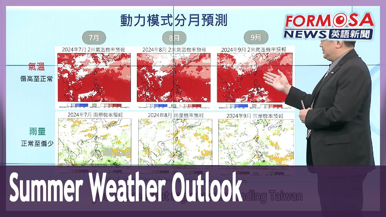
Wu Wan-hua
Central Weather Administration
The next few days will be hot, hot, hot. We’re all feeling it already. On Wednesday and Thursday, the impact of the Pacific high will send temps even higher, particularly in the Taipei basin, western inland areas near mountains, and the Huadong Valley. We’re likely to see localized highs of 36 and 37 degrees Celsius.
Taiwan has endured days of sweltering heat. According to the health ministry, 460 people have sought treatment for heat-related illnesses since June 1. With summer getting underway, more heat is in the forecast.
Chen Yi-liang
Central Weather Administration
As for temperatures, in July, August, and September, you can see that regions surrounding Taiwan are predominately red, indicating higher temperatures. As for rainfall, levels are likely to range from average to below-average.
As for the upcoming typhoon season, forecasters expect just two to four tropical storms to approach Taiwan, which is slightly below the typical range of three to five. Compared to the past, this season’s storms are likely to form closer to Taiwan.
Chen Yi-liang
Central Weather Administration
Storms in La Nina years are more likely to form closer to Taiwan. According to the latest data from climate models, we predict the highest probability of seeing two to four tropical storms. This forecast is slightly below the average range.
Ahead of typhoon season, the Central Weather Administration has optimized its warning systems to improve disaster preparedness.
For more Taiwan news, tune in:
Sun to Fri at 9:30 pm on Channel 152
Tue to Sat at 1 am on Channel 53
氣象署指今夏偏熱雨少 "侵台颱風"可能約2~4個
2024-06-25
最近天氣越來越熱,各地高溫普遍32到36度之間,甚至出現超過38度高溫,隨著七月即將進入颱風季,氣象署也公布夏季天氣展望,今年7到9月氣溫可能偏熱,雨量偏少,下半年侵襲台灣的颱風數量,會較正常年來得少,約2到4個。
火辣太陽,把全台燒成紅蕃薯,氣象署針對14縣市發布高溫警戒。
[[氣象署簡任技正 伍婉華]]
“這幾天,熱、熱、熱,大家都已經明顯地感受到,星期三、星期四,太平洋高壓影響,各地熱的情況更為地顯著,尤其在大台北盆地,西半部近山區的內陸,還有花東縱谷,容易出現局部性,36度、37度的高溫”
最近天氣,白天高溫炎熱,根據衛福部統計,6月至今因為熱傷害就醫人數,全台累計460人次,隨著台灣進入夏季天氣型態,恐怕還會繼續熱下去。
[[氣象署預報中心主任 陳怡良]]
“氣溫的話,從7月、8月到9月,我們都可以看到,台灣附近都是以偏紅的色系,也就是溫度偏高為主,那在雨量的部分呢,就是以正常到偏少的機率比較高”
至於颱風季,以往鄰近台灣的颱風會是3到5個,今年預測值是2到4個,屬於正常偏少,但生成位置會比較靠近台灣。
[[氣象署預報中心主任 陳怡良]]
“反聖嬰年的颱風,是有機會離台灣比較近而生成的,最新的氣候模式的統計預報,可以看到今年的最新的預測,是2到4個的颱風是機率比較高,所以它預報的機率部分,是有正常偏少這樣子的趨勢”
台灣水情除了靠梅雨季、颱風到訪也是重要關鍵,氣象署也強化預警系統,做好防颱準備。
更多新聞內容,請鎖定:
民視台灣台(152頻道)週日至週五晚上9:30
民視新聞台(53頻道)週二至週六凌晨1:00
Related News