Extremely heavy rain batters central and southern regions
Extremely heavy rain batters central and southern regions
2025-07-28
Although Tropical Storm Co-may is still lingering near Okinawa, its periphery is delivering heavy rainfall to many areas of Taiwan. That’s especially so in the south, with widespread flooding in several cities and counties. The Central Weather Administration estimates that the rain will only subside by Thursday in most of the country.
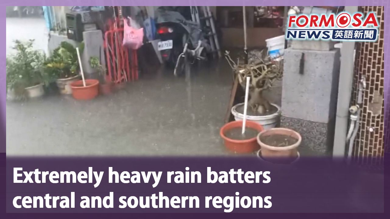
As extremely heavy rain plunders Chiayi, the county government called off work and classes on Monday morning. Among all townships in Chiayi, Taibao recorded the heaviest precipitation, at over 440mm as of 6 p.m. Monday. Even a TSMC site located in the area was flooded.
The rain even began leaking through the roof, so workers did not put away their rain gear. Many of them pulled up a stool and sat down to pass the time. Over in the corner, the flooding was already seeping into the aircons.
Over in the southwest, large swathes of Puzi City were flooded over due to the low-lying terrain and ground subsidence. Many residential buildings, streets and schools were severely affected. Locals could only build sandbag barriers and move their vehicles to lessen the damage.
Meanwhile, in Tainan’s Houbi District, many streets became veritable streams, and the floods even reached local homes. The city government’s disaster response center dispatched two military trucks, and had military personnel hand out bento boxes and relocate local residents.
Flooding was also reported in Yunlin’s Shuilin Township and Taichung’s coastal Dajia and Da’an Districts, among others. Unfortunately, relief from the rain will not come anytime soon.
Chu Mei-ling
Central Weather Administration
Southwesterly winds near Taiwan will strengthen into a current. Therefore, rainfall in the central and southern regions will become heavier and heavier.
Tropical Cyclone Co-may brought forth the large low-pressure belt toward Taiwan. Weather conditions remain unstable, and strong southwesterly winds bring in large amounts of moisture. By Tuesday daytime, maximum precipitation levels will gradually move toward mountainous areas, but rainfall in Southern Taiwan will not noticeably subside. The Central Weather Administration puts 24-hour precipitation level estimates at 250mm to 400mm for Kaohsiung and Pingtung, and 200mm to 300mm for Tainan.
Chu Mei-ling
Central Weather Administration
As Co-may gradually moves toward the northwest, Taiwan will eventually be covered under the off-center area of the low pressure belt. Meanwhile the south will be located where strong southwesterly winds are, and as the cyclone gradually moves toward the northwest, the strong winds will also move towards the central and southern regions, and therefore weather conditions will be quite unstable. From the evening of the 28 to Wednesday, the weather conditions will mostly remain as such.
Starting on Thursday, the tropical cyclone will be far off enough that rainfall all across Taiwan will weaken. However, moisture levels will remain high in the south, and the central and southern regions can expect the rain to last another five to six days.
For more Taiwan news, tune in:
Mon to Fri at 9:30 pm on Channel 152
Tue to Sat at 1 am on Channel 53
#weather #rain #flooding #chiayi #kaohsiung #storm
竹節草颱風復活 "拉抬低壓帶"雨彈狂炸中南部
2025-07-28
輕颱竹節草,還在沖繩附近滯留打轉,雖然不登陸台灣,但拉抬了低壓帶,讓台灣籠罩其中,再加上西南風帶入大量水氣,為中南部地區帶來致災性降雨。氣象署也啟動了較大規模或較劇烈豪雨作業。
雨彈狂炸嘉義,嘉義縣政府上午宣布停班停課。雨量最多的太保,截至週一晚上六點,累積降雨量突破440毫米。連台積電廠房都淹水。
外頭下大雨,裡頭也在下小雨,雨衣、雨傘都不用收,不少人索性拉板凳坐著發呆,辦公區的冷氣機台也泡水。
嘉義縣朴子市因地勢低窪與地層下陷,導致全市大範圍積水,多處住宅、道路、學校嚴重淹水,居民自救搬沙包、移車因應。
台南市後壁區,多處道路淹成小河,也淹進民宅。市府災害應變中心,緊急調度,兩台軍卡與熱食便當,由國軍幫忙發送,並安置居民。
其他像是雲林縣水林鄉、台中海線的大甲、大安等區域都傳出淹水災情。而這雨還會持續下。
[[氣象署資深預報員 朱美霖]]
“台灣附近的西南風會進一步的增強,來到西南氣流的等級,也因此在中南部這一帶的降雨,會越來越劇烈。”
輕颱竹節草,拉抬大低壓帶,來到台灣周邊。不穩定天氣,再加上強勁西南風,帶來大量水氣。到了周二白天,降雨極值往山區移動,但南部地區雨勢並不會顯著趨緩。氣象署預估24小時雨量預測,高屏達250到400毫米,台南也有200到300毫米。
[[氣象署資深預報員 朱美霖]]
“隨著它(竹節草)逐漸的往西北方向移動,台灣逐漸的進入到低壓帶的比較偏向中間的位置,而在南邊都是比較強的西南風所在的位置,隨著颱風逐漸往西北方向移動,這樣子的強風軸也會來到台灣的中南部的附近,也因此天氣上面會相當的不穩定,從今天(28)晚間到週三這段期間,大致上面都是處於這樣子的環境形態。”
週四開始,颱風遠離,全台降雨趨緩,但南部地區水氣仍多。這雨還要下至少五六天,提醒中南部民眾,不可不慎。
更多新聞內容,請鎖定:
民視台灣台(152頻道)週一至週五晚上9:30
民視新聞台(53頻道)週二至週六凌晨1:00
Related News