Authorities monitor conditions at Matai’an barrier lake with satellite devices
Authorities monitor conditions at Matai’an barrier lake with satellite devices
2025-10-02
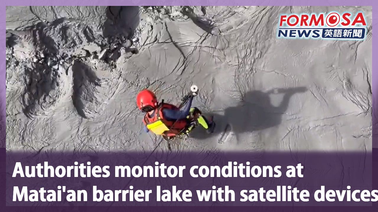
The Forestry and Nature Conservation Agency has carried out an inspection of the barrier lake that overflowed and caused a fatal flash flood in Guangfu Township last week. So far, observations cannot be conducted on-site yet, due to the muddy conditions that prevent a helicopter from landing. Instead, satellite controlled instruments were deployed to collect data. Even though the water is now down to just 6.4% of the pre-disaster volume, the red alert is still in effect.
An airborne service officer lands on the top of the barrier lake from a helicopter, only to get trapped in the mud at once.
The surface is so unstable that one cannot possibly walk on it, let alone land a helicopter here.
Instead, three satellite buoys and a depth sounder were deployed. These devices can remit data through wireless connection.
Chang Tai
Forestry and Nature Conservation Agency
We’re monitoring the changes of the lake for now and making a decision later. We’ll evaluate the volume of water and sediments, the sturdiness of the levee, and the dredging progress. After considering all these factors, we’ll then decide whether to lift the red alert.
The surface of the water at the lake has gone down by 119m to an altitude of 1,020m above sea level. At present, it contains 5.8 million tons of water, which is only 6.4% of what it had before. The red alert is still effective at present.
Chang Tai
Forestry and Nature Conservation Agency
We will issue a red alert when the accumulated rainfall reaches 100mm in 24 hours, or when an earthquake reaches a Weak 5 on Taiwan’s intensity scale. If there’s also a tsunami alert then the affected regions will have to evacuate so as to ensure the public’s safety.
Authorities are keeping a close watch on the lake to avoid another tragedy.
For more Taiwan news, tune in:
Mon to Fri at 9:30 pm on Channel 152
Tue to Sat at 1 am on Channel 53
#guangfu #flooding #disaster #postdisaster #lake
花蓮堰塞湖水量降至6.4% 下游土砂不穩定"維持紅色警戒"
2025-10-02
馬太鞍溪堰塞湖溢流成災,林保署今天申請空勤總隊直升機,到現場探勘,並投放衛星浮標進入堰塞湖,觀測水深,目前堰塞湖蓄水量大約580萬噸,只剩原本的6.4%,,不過,考量仍有水量匯入湖區,下游土砂也不穩定,仍維持紅色警戒。
從直升機垂降到堰塞湖壩頂,特搜教官腳一往下踩,立刻陷進去。
地面狀況太過鬆軟,根本沒辦法走,直升機也無法降落。
最後直接從直升機,投放三枚衛星浮標,還有探深球,未來能透過無線電,回傳水深資料。
[[農業部林保署副署長 張岱]]
“看看這個現場堰塞湖的變化情形,然後再來決定,可能看整個水量淤積的情形,堤防加固的狀況,以及河道疏浚的情形,然後綜合來判斷,是否來解除紅色警戒。”
目前堰塞湖水位下降119公尺,來到1020公尺,蓄水量大約580萬噸,只剩原本的6.4%,不過,下游土砂還不穩定,還有水匯入堰塞湖,目前仍維持紅色警戒
[[農業部林保署副署長 張岱]]
“累積雨量24小時,累積雨量達到100釐米,或是地震5弱的狀況之下,我們會發布紅色警報警戒,那加上這個海嘯警報,這個時候就可能要啟動這個強制疏離、疏散避難,確保民眾的安全。”
就怕堰塞湖再度溢流成災,農業部以更嚴謹的態度,避免災害再度發生
更多新聞內容,請鎖定:
民視台灣台(152頻道)週一至週五晚上9:30
民視新聞台(53頻道)週二至週六凌晨1:00
Related News