CWA issues land warning for Typhoon Usagi
CWA issues land warning for Typhoon Usagi
2024-11-14
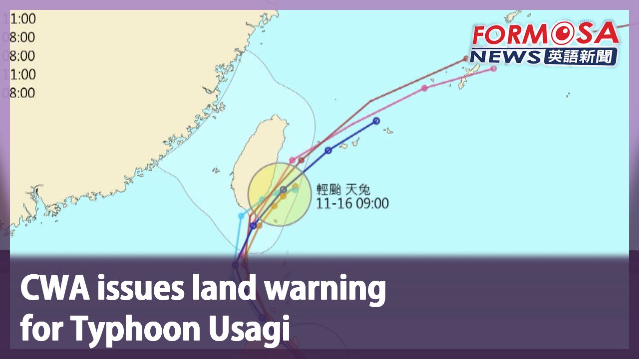
The Central Weather Administration had issued a land warning for Typhoon Usagi in Pingtung and the Hengchun Peninsula, where the storm is expected to make landfall. Meteorologists say the typhoon may weaken before landing in Taiwan, as conditions out at sea in the Bashi Channel are not conducive to its strengthening. They say that, although the storm is currently on track to hit Taiwan, the North Pacific High could cause it to follow a different path. Let’s hear from the Central Weather Administration.
Wu Wan-hua
Central Weather Administration
The eye of the storm is likely to pass across the southern tip of the island before moving northeast. As the storm traverses the Bashi Channel, its structure is becoming weaker, which is further enhanced by the North Pacific High. If it is downgraded into a tropical storm, its direction will be directed by conditions lower down in the atmosphere, so its expected path may change. And if the path is different, its impact will be different as well.
Hualien, Taitung and the Hengchun Peninsula are expected to see the most rainfall on Friday afternoon. Taitung and the Hengchun Peninsula may see localized extremely heavy downpours, while localized heavy showers are expected in Hualien. Wet weather is expected in all other areas of the island.
For more Taiwan news, tune in:
Sun to Fri at 9:30 pm on Channel 152
Tue to Sat at 1 am on Channel 53
颱風"天兔"逼近! 氣象署週四傍晚發布陸警
2024-11-14
中度颱風天兔離台灣越來越近,氣象署傍晚五點半針對屏東、恆春半島發布陸上颱風警報。就目前路徑來看,很有可能會從恆春半島登陸。不過現在巴士海峽條件,不適合颱風發展,還有減弱的可能,太平洋高壓強弱也會影響方向。
[[氣象署簡任技正 伍婉華]]
“(16號)清晨以後它的中心極有可能,也可能會通過我們南端陸地,再往東北的方向移動。颱風移到巴士海峽,它減弱的結構狀況,以及太平洋高壓它減弱情形,還有颱風的結構,它如果輕度颱風,可能會受到比較低層大氣導引的情況會比較多,就會讓它的移動方向就會不一樣,一旦移動方向不一樣,產生的效果也不同。”
週五下半天,花東、恆春半島將會是下雨巔峰,台東、恆春半島出現局部性豪雨,花蓮局部性大雨,其他地區,東北部、北部、中南部,雨勢也會逐漸明顯。
更多新聞內容,請鎖定:
民視台灣台(152頻道)週日至週五晚上9:30
民視新聞台(53頻道)週二至週六凌晨1:00
Related News